This guidance comes from a very useful
3 Peaks site (www.thethreepeakschallenge.com):
Ben Nevis
Ben Nevis lies
in the Scottish Highlands, near Fort William, and the track we took was
the established tourist route from the Glen Nevis Youth Hostel, (GR
128718). This is classed as the most practical short route, and involves
a steep climb from the Youth Hostel, rather than the longer but
shallower starting point from the track that starts behind the
distillery on the A82 by Achintree, (GR 126729). This Pony track route
was constructed to service the meteorological observatory that opened in
1883, and remains wholly intact. It traverses the SW side of Meall an t-Suidhe,
then zigzags the broad west slopes of Ben Nevis to the exposed summit
plateau, and consists of a rocky path over steep boulder fields. The
problems encountered on this route include the cornices at the head of
Gardyloo Gully and Tower Gully, mistaken descent into Five Finger Gully
and crossing the top of Red Burn. Despite all this, the Pony Track
remains the safest route to take. Ben Nevis is 1344m (4409ft) high, and
involves 1325m (4347ft) of climbing from the Hostel which is 30 m above
sea level. The route difficulty is regarded as intermediate to strenuous
and the distance from the start to the summit is approximately 4.75
miles (7.6km).
Snow remains on
the top of Ben Nevis well into the summer making it particularly
hazardous. In low visibility conditions it is wise to use a map and
compass and follow the
recommended route of descent.
Maps
OS Landranger
(1:50,000) no 41. Outdoor Leisure 1:25,000 no 38: Harvey's Walkers Map
(1:40,000), and Superwalker (1:25,000) Ben Nevis - this includes a
1:12,500 enlargement of the Ben's summit.
Tourist
Information: Fort William.
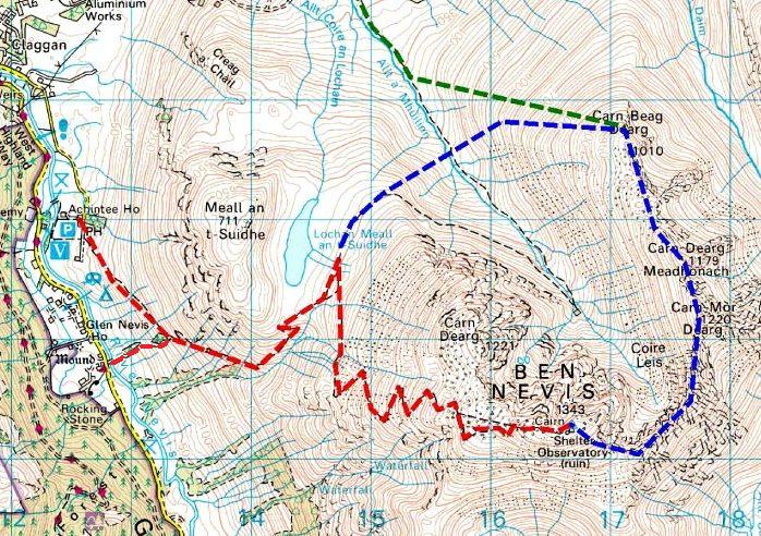
We
started out from the Glen Nevis Youth Hostel marked with the telephone
symbol.
Scafell
Pike
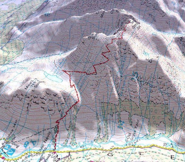
Scafell Pike
involves a mere 913m (2995ft) of climbing, and is the smallest of the
three mountains on the challenge at 977m (3206ft). Past experience from
other walkers suggests that the best route to choose is the one starting
from the National Trust Camp site at Wasdale Head, (GR 181076). Starting
at Seathwaite has its advantages in that it's easier to get to from
Scotland, and saves total driving time, but the walk itself takes a lot
longer. Also navigation from this side is more difficult in low
visibility conditions or at night. We all felt that we made the right
decision by starting out at Wasdale Head. Whichever way you climb
Scafell, it's always going to be tough. It's not a very touristy
mountain like Ben Nevis, and especially Snowdon, which has a cafe and a
train station at the top. Thus you are going to find yourself on a
rubbish track rather than a well-groomed motorway. Scafell was
unpleasant and it was probably just as well that we climbed it in the
dark, and got it over and done with. The terrain is a rocky path from
rough crag to scree and has a rock summit. The route difficulty is
regarded as strenuous. The distance from the start to the summit is
approximately 2.5 miles (4km).
Maps
OS Landranger
(1:50,000) no 90 and 89: OS Outdoor Leisure (1:25,000) no 6 and 4:
Harvey's Walkers Map (1:40,000) and Superwalker (1:25,000) Lakeland
West.
Tourist
Information: Windermere, Keswick or Ambleside.
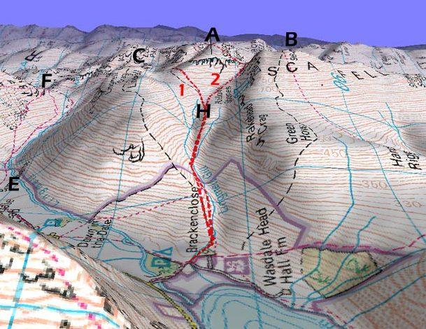
A
=
Scafell Pike
B
=
Scafell
C
= Lingmell
E
=
Wasdale Head
F
= Styhead Pass
H
=
Hollow Stones
1
= Route via
Brown Tongue (the route we took)
2
= Route via
Mickledore
Mount
Snowdon
Snowdon is the
mountain that I have visited most frequently, and the one that I regard
as the nicest. I've climbed it from three directions: The 5 mile
Llanberis path that follows close to the railway, The traverse over Crib
Goch, and the Miners' Track that starts out at Pen-Y-Pass. Of the three
routes, the Llanberis Path is the flattest but the longest. Crib Goch,
which is a sharp arete can be downright dangerous and bad for those with
vertigo, while the Miners' track which is relatively flat until the
later, short, sharp, steeper sections are reached is probably the best.
Originally an access track to the mines, the Miners' track begins with
an easy gradient to Llyn Llydaw and then onto Glaslyn, after which it
joins the Pyg track and zigzags up to Bwlch Glas. The Pyg Track which
lies parallel to the Miners' track also starts from Pen-Y-Pass but is
slightly higher up and slightly more difficult. The total ascent from
the Pen-Y-Pass starting point is 725m (2381ft) with the summit standing
at 1085m (3560ft). The terrain consists of a rocky path and craggy
corries with a steep headwall climb to an exposed col (Bwlch Glas) which
leads on to a broad summit ridge up by the railway track. The route
difficulty is regarded as intermediate, and from the start to the summit
the distance is approximately 4 miles (6.4km). The return route follows
the same path. Remember though to stop the watch at Pen-Y-Pass car park
on the way back, hopefully under 24 hours. (GR 647557.)
Maps
OS Landranger
(1:50,000) no 115: OS Outdoor Leisure (1:25,000) no 17: Harvey's Walkers
Map (1:40,000) and Superwalker (1:25,000) Snowdonia West.
Tourist
information: Llanberis.
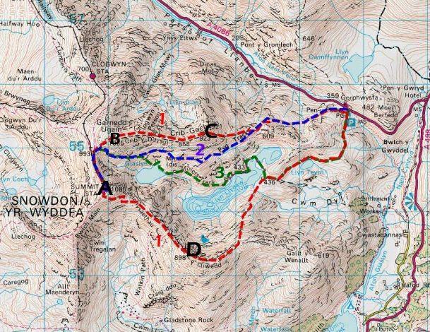
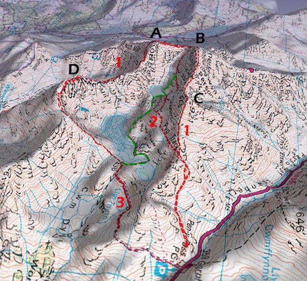
A
= Yr Wyddfa
(Snowdon)
B
= Garnedd Ugain
C
=
Crib Goch
D
= Y Lliwedd
1
= Snowdon Horseshoe
2
=
PYG Track
3
= Miners
Track (the route we took in green)
Mountain time breakdowns
Most
challengers start their watches at the bottom of Ben Nevis and stop them
at the bottom of Mount Snowdon. There is much speculation though as to
which time of day you should start. Our original plan to start at
06.00hrs would have meant us being at the respective summits at
09.00hrs, 20.10hrs and 04.30hrs. We didn't really want to finish so
early in the morning though and so therefore followed the schedule
below. The times are accurate as we had a databack facility on our
cameras (very useful for working out how well you did when you get
home).
Schedule
15.00 base of
Ben Nevis
18:00 summit of Ben Nevis
20:00 base of Ben Nevis
02.45 base of
Scafell Pike
05:10 summit of Scafell Pike
06:30 base of Scafell Pike
11.15
base of Snowdon
13.30 summit of Snowdon
14.35 base of Snowdon
|